NASA-ISRO Radar Mission Peers Through Clouds to See Mississippi River Delta
Unveiling the Secrets of the Mississippi River Delta: NASA-ISRO Radar Mission's Groundbreaking Discovery
The Mississippi River Delta, a region of immense ecological and economic importance, has long been shrouded in mystery. The dense forests, vast wetlands, and sprawling cities of this area have made it a challenging terrain to map and study. However, thanks to the innovative NASA-ISRO Synthetic Aperture Radar (NISAR) mission, scientists have now been able to peer through the clouds and reveal the secrets of this region in unprecedented detail.
The Power of Radar Technology
The NISAR mission, a joint collaboration between NASA and the Indian Space Research Organisation (ISRO), has been equipped with two SAR instruments that operate at different wavelengths. The L-band SAR, which employs microwaves with a 9-inch wavelength, can pass uninterrupted through clouds and image the surface below clearly. This technology has allowed scientists to create high-resolution maps of the Mississippi River Delta, revealing the diverse range of land cover types, including forests, wetlands, and agricultural areas.
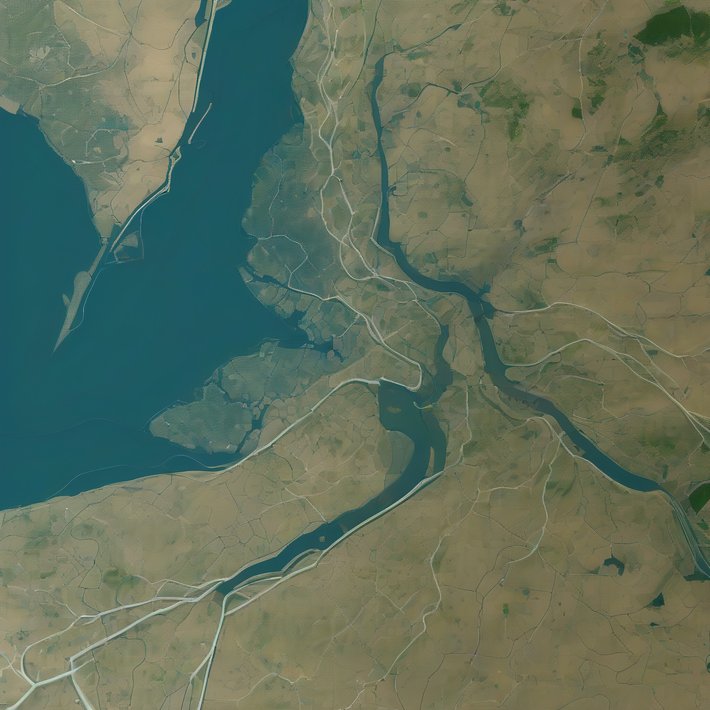
A Close-Up Look at the Mississippi River Delta
The image captured by NISAR's L-band SAR instrument on November 29, 2025, shows the cities of New Orleans and Baton Rouge, the Mississippi River, Lake Pontchartrain, and a range of wetlands, farmlands, and populated areas. The colors in the image indicate different types of land cover, with healthy forests appearing bright green, thinned tree populations showing yellow-and-magenta hues, and tall crops appearing bright magenta.
The Importance of NISAR's Discovery
The NISAR mission's discovery has significant implications for various fields, including disaster response, infrastructure monitoring, and agricultural management. By providing unique, actionable information to decision-makers, NISAR can help protect communities and support sustainable development. For instance, the mission's data can be used to monitor the health of forests and wetlands, track the progress of crops, and identify areas prone to flooding.
The Science Behind NISAR's Technology
The NISAR satellite is equipped with a giant drum-shaped reflector, which measures 39 feet wide and is the largest radar antenna reflector NASA has ever sent into space. This reflector allows the satellite to collect data using the spacecraft's S-band SAR, which operates at a wavelength of 4 inches. The combination of these two SAR instruments enables NISAR to monitor Earth's land and ice surfaces twice every 12 days.
The Future of NISAR and Its Applications
The NISAR mission is set to make thousands of mission data files available for download in late February. This will provide researchers and scientists with a wealth of information to study the Earth's surface and understand the impact of climate change. The mission's data can be used to support a range of applications, including disaster response, infrastructure monitoring, and agricultural management.
Conclusion
The NISAR mission's discovery has opened up new possibilities for scientists to study the Earth's surface and understand the impact of climate change. The mission's data can be used to support a range of applications, including disaster response, infrastructure monitoring, and agricultural management. As the mission continues to collect data, we can expect to see new insights and discoveries that will help us better understand our planet and support sustainable development.
Forward-Looking Thoughts
The NISAR mission is just the beginning of a new era in Earth observation. As technology continues to advance, we can expect to see even more sophisticated instruments and missions that will allow us to study the Earth's surface in unprecedented detail. The implications of this technology are vast, and we can expect to see significant advances in fields such as disaster response, infrastructure monitoring, and agricultural management.
Related Topics
- NISAR (NASA-ISRO Synthetic Aperture Radar)
- Earth Science Missions
- Earth Science Data
- Earth Science at Work
- Disaster Response
- Infrastructure Monitoring
- Agricultural Management
Explore More
- Extreme January Cold: Following a significant winter storm, frigid temperatures lingered in late January 2026 across a vast area of the United States.
- March 2026 Total Lunar Eclipse: A total lunar eclipse will redden the Moon on March 3, 2026. Here's what you need to know.
- NASA Analysis Shows La Niña Limited Sea Level Rise in 2025: A new analysis by NASA has found that La Niña had a significant impact on sea level rise in 2025.